
Data-driven innovation.
Driving meaningful change.
By blending qualitative and quantitative user research, our design-thinking approach, data and digital technology, we gain a comprehensive understanding of the needs of people, places, and their environments. This knowledge allows us to shape the future through insights and design, ensuring that your solutions are tailored to meet the evolving demands of our world.

Featured Thoughts
-

Solar Potential on Car-parking Surfaces Around the City of Perth
On the back of a recent article referred by the Committee for Perth looking at the level of land used for parking in cities, our elementcolab team took up the challenge do some quick ideating on the opportunity for solar potential on car parking surfaces around the City of Perth.
-
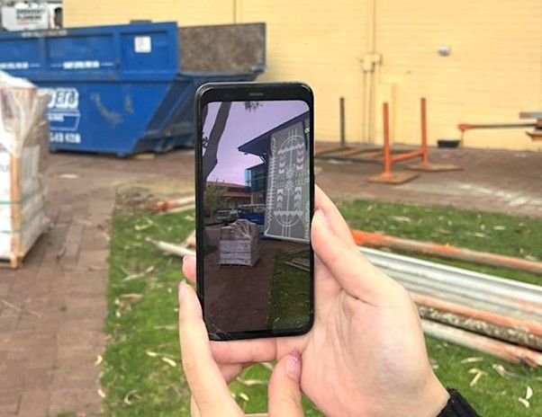
Aiding Decision Making in The Arts with Augmented Reality
With more than 1.4billion people predicted to be using Augmented Reality (AR) devices globally by the end of 2023, there is a powerful role for AR to help shape art and design, engage communities and create conversations.
-
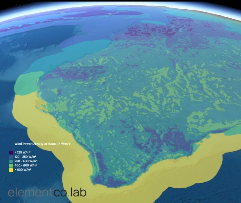
WA Renewable Energy Opportunity: Wind Power Density
On the back of the CEDA - Committee for Economic Development of Australia - 2023 WA Energy Transition Summit and the progressive announcements of the WA Government, there is significant momentum and opportunity for WA across renewables.
Utilizing AI cognitive services within Azure, such as the Form Recognizer, the elementco.lab team developed new workflows to extract data from PDF documents. This service employs machine learning models to identify and extract text, tables, and key-value pairs from PDFs, which can be achieved through a no-code approach with Power Automate and AI Builder. Once the data is extracted, it can be joined with a geospatial layer, in this case the Local Government boundaries within WA. This process involves matching fields between the extracted data and the geospatial data, allowing for the visualization of non-spatial data in a spatial context.
After the data is combined with the geospatial layer, the integrated dataset can be published as a raster map tile. Mapbox provides the functionality to upload and tile quantitative raster data, retaining the numerical character of the data through visualization on a map. The Raster Mapbox Tiling Service (Raster MTS) is a tool specifically designed for this purpose, transforming raster data into raster tiles hosted on Mapbox servers for use in applications. These tiles can then be added to a map using Mapbox GL JS, defining a custom style that includes a raster source with an external URL template for the tiles parameter. This comprehensive workflow leverages the power of Azure's AI cognitive services and Mapbox's mapping capabilities to transform PDF content into interactive and visually informative map tiles.
The elementco.lab team used this workflow on the 2024 WA Local Government Association Directory, displaying this key information within an interactive web-map.